Giannopoulos Nikolaos, Papatheodorou George, Christodoulou Dimitrios, Dimas Xenophon, Sergiou Spyros, and Maria Geraga
Oceanus-Lab, Department of Geology, University of Patras, 26504 Greece
Introduction
A previously unrecognized pockmark field has recently been identified and surveyed in the Patras Gulf, approximately 15 km west of the Patras Gulf Pockmark Field (PGPF)(Christodoulou et al., 2023), a benchmark site for pockmark research in Greece that Judd and Hovland (2007) described as representing “some of the most spectacular and best-documented events in active pockmarks”. The pockmarks were first identified during the Oceanus-Lab's marine remote sensing surveys in the Gulf of Patras. Following their initial discovery, a high-resolution marine geophysical survey was conducted across the pockmark field to investigate the spatial relationship between seafloor morphology, shallow subsurface stratigraphy, active gas seepage, and local tectonic structures. The primary objectives were to produce detailed maps of the seafloor, characterize the geometry and internal architecture of pockmarks, identify shallow gas migration pathways, and assess the influence of faulting on fluid escape processes.
Methodology
The survey employed an integrated suite of state-of-the-art geophysical and imaging systems, including: (i) Multibeam Echosounder (MBES): Used to acquire high-resolution bathymetric data and seafloor backscatter, enabling the detailed mapping of pockmark morphology, seafloor roughness, and other geomorphological features associated with fluid seepage. (ii) High-Resolution Chirp Subbottom Profiler: Provided high-resolution acoustic images of the shallow subsurface stratigraphy, allowing the identification of sedimentary layers, shallow gas accumulations, gas migration pathways, and fault-related deformation beneath the seafloor and acoustic characters related to gas charged sediments (acoustic turbid zone, gas pockets, enhanced reflectors, columnar disturbances, etc.). (iii) Dual-Frequency Side-Scan Sonar: Generated detailed 2D acoustic imagery of the seafloor texture and sedimentary facies, facilitating the detection of gas seep-related features such as carbonate crusts, bacterial mats, sediment disturbances, and small-scale morphological anomalies that may not be evident in bathymetric data alone. (iv) Remotely Operated Vehicle (ROV): Conducted targeted visual inspections of selected sites to provide ground-truth validation of the geophysical interpretations. The ROV documented active seep locations, gas bubble emissions, benthic habitats, and other biological or geological indicators of fluid escape through high-definition video and photographic observations.
Results
The marine geophysical survey revealed the presence of a previously undocumented pockmark field in the Gulf of Patras. Preliminary processing and interpretation of the geophysical datasets identified at least ten (10) pockmarks occurring at water depths of approximately 80–100 m (Fig. 1). The pockmarks are distributed within a NW–SE-oriented zone approximately 1.5 km long and 300 m wide. Based on their morphology and dimensions, the pockmarks can be classified into two distinct morphological types: (i) large, irregularly elliptical craters with maximum diameters of up to ~200 m, and (ii) smaller, subcircular craters with diameters of approximately 50 m. Three pockmarks belong to the first morphological type, whereas the remaining seven are assigned to the second. The irregular elliptical morphology of the larger pockmarks is interpreted as the result of the coalescence of adjacent smaller craters, suggesting the progressive evolution and enlargement of the pockmark structures through repeated or spatially overlapping fluid expulsion events. Interpretation of the seismic profiles revealed the presence of two main seismic sequences (S)(Fig. 2). The upper sequence (S1) is characterized by an acoustically transparent to weakly reflective facies, displaying low-amplitude, subparallel to nearly parallel internal reflections. S1 overlies the lower sequence (S2), which is expressed as a series of, subparallel high-amplitude reflectors. Acoustic penetration beneath S2 was generally not achieved, due to existence of an Acoustic Turbid Zone (ATZ). The uppermost reflector of S2 is interpreted as the Pleistocene–Holocene boundary. A similar seismostratigraphic framework was identified within the Patras Gulf Pockmark Field (PGPF). NW–SE-trending and N- & S-dipping faults, penetrate both seismic sequences and are interpreted as the principal structural conduits controlling pockmark formation. Beneath the pockmarks, acoustic anomalies, including gas pockets and columnar disturbances, provide evidence of upward gas migration through the shallow subsurface (Fig. 2). Targeted R.O.V surveys conducted at selected sites provided ground-truth evidence of active seafloor gas seepage, documenting gas bubble emissions and the development of bacterial mats at seep locations.
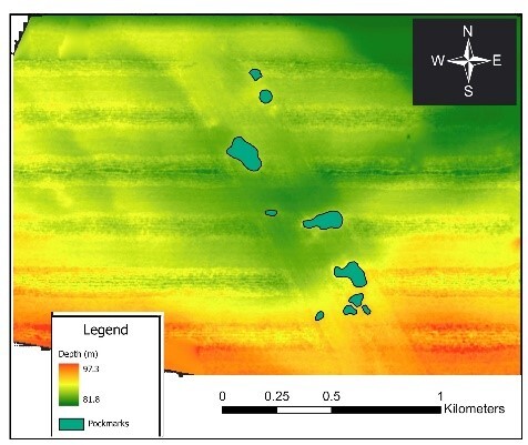
Figure 1. MBES bathymetric map of the pockmark field.
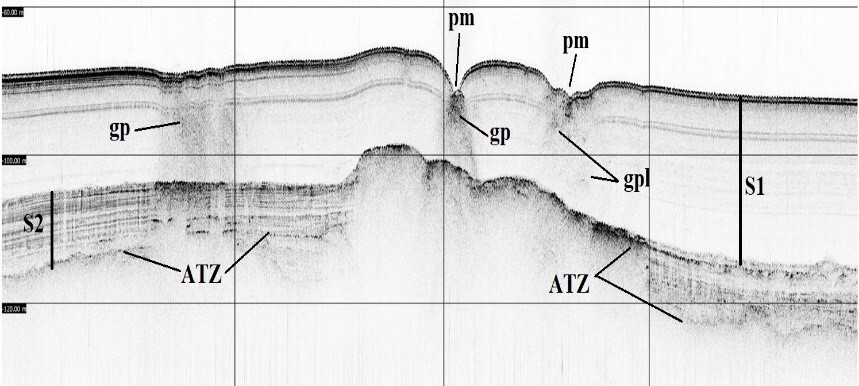
Figure 2. Representative seismic profile acquired within the pockmark field.
(ATZ: acoustic turbid zone, pm: pockmark, gp: gas pocket, gpl: gas plumes, S1: upper seismic sequence, S2: lower seismic sequence ).
Conclusions
The integration of marine geophysical datasets enabled a comprehensive characterization of a new previously unrecognized pockmark field in Patras Gulf, improving the understanding of the interactions between seafloor morphology, shallow geological structures, and active fluid migration processes. The combined geophysical and visual observations also provided valuable constraints on the role of faulting in controlling gas seepage pathways and the evolution of pockmark systems.
References
Christodoulou, D., Papatheodorou, G., Geraga, M., Etiope, G., Giannopoulos, N., Kokkalas, S., Dimas, X., Fakiris, E., Sergiou, S., Georgiou, N., Sokos, E., & Ferentinos, G. (2023). Geophysical and Geochemical Exploration of the Pockmark Field in the Gulf of Patras: New Insights on Formation, Growth and Activity. Applied Sciences, 13(18), 10449. https://doi.org/10.3390/app131810449.
Judd, A.G., & M. Hovland (2007). Submarine Fluid Flow, the Impact on Geology, Biology, and the Marine Environment. Cambridge University Press, 475pp.
https://doi.org/10.1017/CBO9780511535918