Dimitris Christodoulou, Xenophon Dimas, Aris Tziatzopoulos, Alkiviadis Kontos, Maria Geraga, George Papatheodorou
Oceanus-Lab (Laboratory of Marine Geology and Physical Oceanography, Department of Geology), University of Patras, Patras, Greece (dchristo@upatras.gr)
INTRODUCTION
Shallow-water hydroacoustics, specifically high-frequency multibeam echosounders (MBES), serve as the primary tool for isolating vertical gas flares while filtering out ambient surface noise. Furthermore, single beam echosounders could be fast and effective tool for locating flares just below the survey line. This is complemented by side-scan sonar (SSS) and high-resolution sub-bottom CHIRP profilers, which characterize the seabed types and structural expressions of venting, such as pockmarks and subsurface enhanced reflectors, acoustic turbid zones, intrasedimentary gas plumes (Judd and Hovland, 2007; Christodoulou et al., 2023). Submarine hydrothermal activity is widespread in volcanically active settings, including mid-ocean ridges, seamounts, and volcanic arcs, where it plays a key role in regulating heat and chemical exchanges across the seafloor. Systematic mapping is essential for identifying hydrothermal outflow zones, defining their spatial geometry, and documenting temporal variability in hydrothermal discharge.
Numerous submarine fluid seepage sites have been reported around Milos Island, occurring in both shallow and deep-water settings (Nomikou et al., 2025). In coastal environments, such seepage has been documented in Palaiochori Bay, Voudia Bay, and Adamas Bay (Dando et al., 1995; Megalovasilis 2020; Puzenat et al., 2021) Among these areas, Palaiochori Bay represents the only site where systematic mapping and detailed characterization of the discharge zones have been carried out, mainly based on optical datasets, including satellite, aerial, and underwater imagery (Martelat et al., 2020; Khimasia et al., 2020; Puzenat et al., 2021; Oprandi et al., 2025). In Voudia Bay, although seepage sites had been identified during previous surveys using a single beam echosounder, and diving operations, no detailed mapping of the seepage areas or assessment of their relationship with seafloor type had previously been carried out.
METHODOLOGY
A detailed survey in Voudia and Paleochori in Milos Island through a multi-sensor remote-sensing platform was conducted in April 2025 (Fig. 1a). The equipment composition was designed in order to provide high-resolution seafloor mapping and environmental characterization. In detail, an Iter Systems bathyswath swath bathymetric sonar operated at 224kHz, an Edgetech 4200 dual frequency Side Scan Sonar operated simultaneously at 100 and 400kHz, a Kongsberg GeopulsePlus high resolution Chirp subbottom profiler and a Biosonics MX Aquatic Habitat single beam echosounder (SBES) were used and operated simultaneously during the survey. To obtain very high-resolution data, a dense survey-line network was designed, consisting of both shore-parallel and shore-perpendicular transects spaced at 50 m intervals. Finally, visual data for ground-truthing of both seafloor typology and seepage classification was carried out using an ROV equipped with an ultra-high-definition camera.
RESULTS
Data processing resulted in the generation of high-resolution bathymetric maps, side-scan sonar mosaics, and seafloor classification maps for both study bays. Seafloor-type classification was based on an integrated interpretation of seabed morphology and the acoustic backscatter characteristics of the substrate.
Fluid seepage was identified using all geophysical survey systems. In the side-scan sonar records, seepage manifestations were detected as acoustic flares within the water column and as localized high-backscatter patches associated over the seafloor reflection (Fig. 1c). Sub-bottom profiler data revealed fluid seepage both in the water column, where it appeared as acoustic flares, and predominantly beneath the seafloor, where it was expressed as acoustic turbidity zones and enhanced reflectors, indicative acoustic characteristics of shallow gas accumulation and fluid migration (Fig. 1d). The spatial distribution of these near-seafloor acoustic anomalies closely corresponds to the locations of the water-column acoustic anomalies identified in the side-scan sonar data.
Seepage density was quantified primarily using single-beam echosounder (SBES) data. Owing to its narrow conical acoustic beam, originally designed for macrophyte and canopy height detection, this system provides high spatial resolution and enables the accurate detection and discrimination of gas bubbles within the water column (Fig. 1b).
In Palaiochori Bay, more than 700 seepage features, including both individual venting sites (Fig. 1e) and clusters of multiple seepage vents (Fig. 1f), were identified from the single-beam echosounder (SBES) data. A comparable number of seepage features (>500) was also detected in Voudia Bay. The mapped seepage distribution in Palaiochori Bay extends considerably beyond the areas previously reported, demonstrating that fluid venting continues into the deeper part of the bay. In contrast, this study provides the first comprehensive delineation of the spatial extent of the seepage field in Voudia Bay, where previous investigations had documented only isolated point-source seepage occurrences.
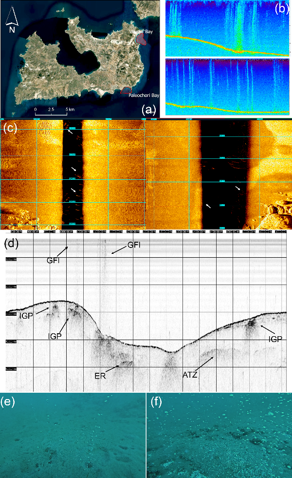
Figure 1. Surveyed areas in Milos island (a); Gas flares detected in SBES (b); in Side Scan Sonar records (c); Enhanced Reflectors (ER), Acoustic Turbid Zone (ATZ), Intrasedimentary Gas Plumes (IGP) and Gas Flares (GFl) depicted in Subbottom profiles (d) and ROV images showing (e) isolated small-scale seepages and (f) areas of intense seepage activity.
Ground-truth observations acquired using the ROV confirmed the geophysical interpretations. A distinct difference was observed between weak, isolated acoustic reflections within the water column, interpreted as individual point-source seepage events, and stronger, spatially overlapping acoustic anomalies, which are indicative of vigorous fluid discharge from clusters of closely spaced seepage vents distributed over broader areas.
CONCLUSIONS
The multi-platform high detail marine geophysical survey conducted in two areas with confirmed hydrothermal seepage demonstrated that this approach could serve as an important tool for the detailed mapping of shallow water seepage activity, associated seabed features and related seabed types. These results provide a robust basis for the planning of subsequent investigations, including targeted sampling and in situ geochemical analyses at representative sites. The consequently integration of these datasets will contribute to a more accurate assessment of seepage rates and fluxes, and finally to a better evaluation and understanding of the overall potential of the seepage field.
REFERENCES
Christodoulou, D. Papatheodorou, G., Geraga,. et al. Geophysical and Geochemical Exploration of the Pockmark Field in the Gulf of Patras: New Insights on Formation, Growth and Activity. Applied Sciences 2023, 13, 10449
Dando, P.R., Hughes, J.A., Leahy, Y., Niven, S.J., Taylor, L.J., Smith, C., 1995a. Gas venting rates from submarine hydrothermal areas around the island of Milos, Hellenic Volcanic Arc. Continental Shelf Research 15, 913–929.
Judd, A.G. and Hovland, M. Seabed Fluid Flow: The Impact of Geology, Biology and the Marine Environment; Cambridge University Press, 2007; ISBN 9780521819503.
Khimasia, A., Rovere, A., Pichler, T., 2020. Hydrothermal areas, microbial mats and sea grass in Paleochori Bay, Milos, Greece. Journal of Maps 16 (2), 348–356.
Martelat, J.E., Escartín, J., Barreyre, T., 2020. Terrestrial shallow water hydrothermal outflow characterized from out of space. Marine Geology 422, 106119.
Megalovasilis P. 2020. Geochemistry of Hydrothermal Particles in Shallow Submarine Hydrothermal Vents on Milos Island, Aegean Sea East Mediterranean. Geochemistry International, 2020, 58 (2), 151–181
Nomikou P., Bejelou K., Koschinsky A., et al. 2025 Structural control and depth clustering of extensive hydrothermal venting on the shelf of Milos Island Scientific Reports, 15 (1), 42359
Oprandi, A., Bianchi, C.N., Morri, C., Canessa, M. 2025. Are shallow-water hydrothermal vents stable? A comparison of published maps of the Paleochori Bay (Milos, Greece) systems twenty years apart. Continental Shelf Research, 291, 105494
Puzenat, V., Escartín, J., Martelat, J.E., et al., 2021. Shallow-water hydrothermalism at Milos (Greece): nature, distribution, heat fluxes and impact on ecosystems. Marine Geology 438, 106521
AKNOWLEGEMENTS
Τhis paper has been financed by the Vodafone Posidonia Project .and funding programme “MEDICUS”, of the University of Patras